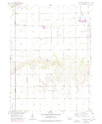
1958 Map of Columbus SE
USGS Topo · Published 1977About this map
The agrarian landscape of the Alexis and Summit townships is defined by a dense network of sections and township boundaries near the Polk Co Butler Co line. In the northern reaches, the Chicago Burlington and Quincy railroad cuts through the terrain, passing near several Gravel Pits and the Bellwood Cem. Rural life in this era was anchored by local institutions such as St Joseph Ch, School No 13, and the Brown Sch, which served the farming families of the Savannah and Creek districts.
Find a feature on this map
23 named features on this map. Tap any name to fly to it.
Don’t see what you’re looking for? This feature index may not catch every label — zoom into the map to look around manually.
Map Details
Editions of this 1958 Columbus SE Map
2 editions found
Other maps of this area

1899 · David City
USGS Topo · 1:125,000

1955 · Fremont
USGS Topo · 1:250,000

1957 · Fremont
USGS Topo · 1:250,000

1958 · Fremont
USGS Topo · 1:250,000

1958 · Duncan
USGS Topo · 1:24,000

1958 · Columbus SW
USGS Topo · 1:24,000

1958 · Columbus SE
USGS Topo · 1:24,000

1958 · Columbus
USGS Topo · 1:24,000
1965 · Shelby
USGS Topo · 1:24,000
1965 · Garrison
USGS Topo · 1:24,000