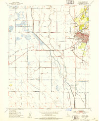
1952 Map of Colusa
USGS Topo · Published 1953About this map
The Sacramento River defines the eastern edge of this landscape, its sharp meanders forming Cobbs Bend and Arnold Bend near the established river town of Colusa. By the early 1950s, the community had developed significant infrastructure, including the Union High Sch, Mem Hosp, and the County Fairgrounds. The Southern Pacific railroad cuts through the heart of town, while the Colusa Airport sits just to the south.
Find a feature on this map
38 named features on this map. Tap any name to fly to it.
Don’t see what you’re looking for? This feature index may not catch every label — zoom into the map to look around manually.
Map Details
Editions of this 1952 Colusa Map
4 editions found
Other maps of this area

1888 · Marysville
USGS Topo · 1:125,000

1891 · Marysville
USGS Topo · 1:125,000

1894 · Marysville
USGS Topo · 1:125,000

1895 · Marysville
USGS Topo · 1:125,000

1906 · Maxwell
USGS Topo · 1:62,500

1907 · Colusa
USGS Topo · 1:62,500

1911 · Sanborn Slough
USGS Topo · 1:31,680

1911 · Grimes
USGS Topo · 1:31,680

1912 · Meridian
USGS Topo · 1:31,680

1917 · Compton Landing
USGS Topo · 1:31,680