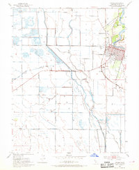
1952 Map of Colusa
USGS Topo · Published 1969About this map
The Sacramento River meanders along the eastern edge of this mid-century survey, defining the landscape with dramatic curves like Arnold Bend and Cobbs Bend. The city of Colusa serves as the regional hub, showing a grid of streets including Northern St and Market St, while institutional landmarks like the Colusa Union High Sch and the County Fairgrounds anchor the community. The infrastructure reflects a heavy reliance on water management and recreation, evidenced by the numerous pump houses and sporting associations such as the Colusa Gun Club and Northern Gun Club.
Find a feature on this map
44 named features on this map. Tap any name to fly to it.
Don’t see what you’re looking for? This feature index may not catch every label — zoom into the map to look around manually.
Map Details
Editions of this 1952 Colusa Map
4 editions found
Other maps of this area

1888 · Marysville
USGS Topo · 1:125,000

1891 · Marysville
USGS Topo · 1:125,000

1894 · Marysville
USGS Topo · 1:125,000

1895 · Marysville
USGS Topo · 1:125,000

1906 · Maxwell
USGS Topo · 1:62,500

1907 · Colusa
USGS Topo · 1:62,500

1911 · Sanborn Slough
USGS Topo · 1:31,680

1911 · Grimes
USGS Topo · 1:31,680

1912 · Meridian
USGS Topo · 1:31,680

1917 · Compton Landing
USGS Topo · 1:31,680