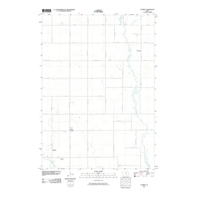
2010 Map of Colwell
USGS Topo · Published 2010About this map
Colwell serves as the primary hub of this Floyd County landscape, which is defined by its rectilinear grid of rural roads and the meandering courses of several vital waterways. The Wapsipinicon River snakes along the eastern edge of the quadrangle, while the Little Cedar River and Beaver Creek cut through the southwestern and southern sections. This 2010 survey illustrates a quiet agricultural area punctuated by established burial grounds such as Saint Patricks Cemetery and Beckwith Cemetery, providing clear landmarks for genealogical research. The small settlement of Nilesville sits in the southwest, anchoring a network of thoroughfares like Victory Ave and Walnut Ave that facilitate movement between these isolated prairie communities.
Find a feature on this map
31 named features on this map. Tap any name to fly to it.
Don’t see what you’re looking for? This feature index may not catch every label — zoom into the map to look around manually.
Map Details
Editions of this 2010 Colwell Map
This is the sole edition of this map. No revisions or reprints were ever made.
Other maps of this area

1954 · Mason City
USGS Topo · 1:250,000

1957 · Mason City
USGS Topo · 1:250,000

1958 · Mason City
USGS Topo · 1:250,000

1971 · Charles City
USGS Topo · 1:24,000

1971 · Bassett
USGS Topo · 1:24,000

1971 · Colwell
USGS Topo · 1:24,000

1971 · Floyd
USGS Topo · 1:24,000

1972 · New Haven
USGS Topo · 1:24,000

1972 · Riceville
USGS Topo · 1:24,000
1972 · Ionia
USGS Topo · 1:24,000