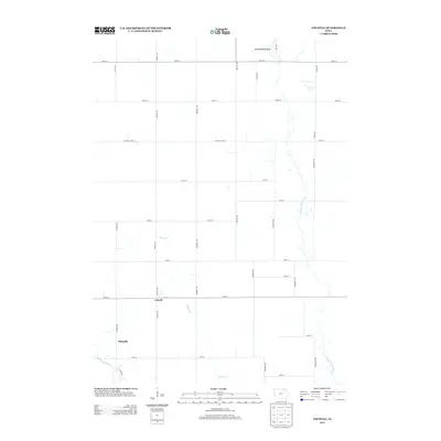
2013 Map of Colwell
USGS Topo · Published 2013About this map
Colwell serves as the primary hub for this agricultural portion of Floyd County, where the straight-line precision of the Midwest section grid is defined by routes like Colwell Ave and 1st St. The landscape is a study in Iowa's critical drainage networks, anchored by the meandering Wapsipinicon River to the east and the Little Cedar River clipping the southwest corner. The transition from active farmland to preserved habitat is visible at the Elma Wildlife Area along the northern border. Smaller settlements like Nilesville appear as modest clusters along Victory Ave, illustrating the historical distribution of rural communities. The map highlights the intersection of local infrastructure and natural waterways, including several branches of Beaver Cr that feed into the larger river systems, demonstrating how the terrain dictates the placement of rural roads like Mitchell Line St.
Find a feature on this map
34 named features on this map. Tap any name to fly to it.
Don’t see what you’re looking for? This feature index may not catch every label — zoom into the map to look around manually.
Map Details
Editions of this 2013 Colwell Map
This is the sole edition of this map. No revisions or reprints were ever made.
Other maps of this area

1954 · Mason City
USGS Topo · 1:250,000

1957 · Mason City
USGS Topo · 1:250,000

1958 · Mason City
USGS Topo · 1:250,000

1971 · Charles City
USGS Topo · 1:24,000

1971 · Bassett
USGS Topo · 1:24,000

1971 · Colwell
USGS Topo · 1:24,000

1971 · Floyd
USGS Topo · 1:24,000

1972 · New Haven
USGS Topo · 1:24,000

1972 · Riceville
USGS Topo · 1:24,000
1972 · Ionia
USGS Topo · 1:24,000