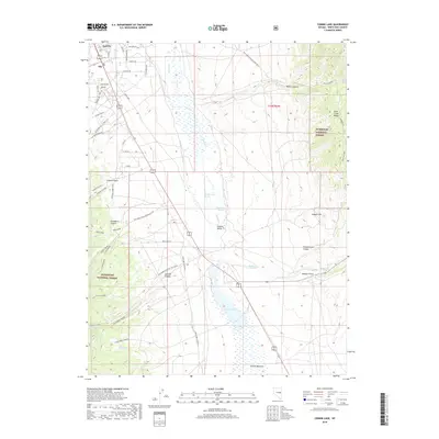
2018 Map of Comins Lake
USGS Topo · Published 2018About this map
The high-desert landscape surrounding Ely and East Ely is defined by the broad Steptoe Valley and the rising slopes of the Duck Creek Range. This 2018 survey detail shows a network of roads extending from the urban core toward the Humboldt National Forest, where numerous canyons like Mosier Canyon and Lowry Canyon cut into the mountains. A vital hydrologic system is visible through the valley floor, centered on Comins Lake and the adjacent Comins Meadow, fed by seasonal flows from Steptoe Cr. Local water sources are mapped with precision, including Shallenberger Spring, Fish Pond Springs, and Blackrock Spring. To the southeast, Monitor Field occupies a level stretch of ground near the mountain foothills. The map documents the interface between modern residential developments, such as Heritage Dr and Marich Way, and the vast public lands that characterize this part of White Pine County.
Find a feature on this map
46 named features on this map. Tap any name to fly to it.
Don’t see what you’re looking for? This feature index may not catch every label — zoom into the map to look around manually.
Map Details
Editions of this 2018 Comins Lake Map
This is the sole edition of this map. No revisions or reprints were ever made.
Other maps of this area

1952 · Ely
USGS Topo · 1:125,000

1956 · Ely
USGS Topo · 1:250,000

1958 · Ruth
USGS Topo · 1:24,000

1958 · East Ely
USGS Topo · 1:24,000

1958 · Comins Lake
USGS Topo · 1:24,000

1958 · Ely
USGS Topo · 1:62,500

1958 · McGill
USGS Topo · 1:62,500

1958 · Ely
USGS Topo · 1:24,000

1959 · Ely
USGS Topo · 1:250,000

1959 · Connors Pass
USGS Topo · 1:62,500