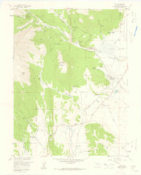
1957 Map of Como
USGS Topo · Published 1959About this map
Como serves as the focal point of this late-1950s survey, situated along the Old Railroad Grade in the high-altitude landscape of Park County. The map documents a transition from industrial activity to cattle ranching, marked by numerous family and corporate operations such as the Circle V Bar Eightmile Ranch, Robinson Ranch, and Red Hill Ranch. The mining history of the Pike National Forest is evidenced by the Silverheels Mine and Fortune Placer Mine, while the Welch Sawmill near Holthusen Gulch points to local timber extraction. Education and infrastructure are reflected in the Fremont Sch and the Como Cem. Notable terrain features include Silverheels Mountain and Little Baldy Mountain, with the Boreas Pass Road providing access through the rugged gulches and along North Tarryall Creek.
Find a feature on this map
54 named features on this map. Tap any name to fly to it.
Don’t see what you’re looking for? This feature index may not catch every label — zoom into the map to look around manually.
Map Details
Editions of this 1957 Como Map
4 editions found
Other maps of this area

1889 · Leadville
USGS Topo · 1:125,000

1891 · Leadville
USGS Topo · 1:125,000

1934 · Climax
USGS Topo · 1:48,000

1937 · Como
USGS Topo · 1:62,500

1938 · Mt. Lincoln
USGS Topo · 1:48,000

1942 · Leadville
USGS Topo · 1:125,000

1945 · Mount Lincoln
USGS Topo · 1:62,500

1953 · Denver
USGS Topo · 1:250,000

1956 · Elkhorn
USGS Topo · 1:24,000

1956 · Fairplay East
USGS Topo · 1:24,000