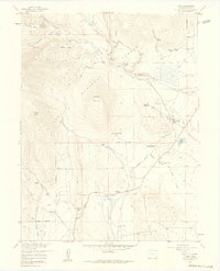
1957 Map of Como
USGS Topo · Published 1959About this map
Silverheels Mountain and Iron Mountain dominate the high-altitude landscape of this 1957 field-checked survey, where the remnants of the Colorado silver and gold mining era are still visible. The settlement of Como serves as the focal point, situated at the edge of South Park where the Old Railroad Grade once facilitated transport for the region's mineral wealth. Evidence of extractive industry is scattered across the terrain, from the Silverheels Mine to the Fortune Placer Mine and several areas of Tailings.
Find a feature on this map
48 named features on this map. Tap any name to fly to it.
Don’t see what you’re looking for? This feature index may not catch every label — zoom into the map to look around manually.
Map Details
Editions of this 1957 Como Map
4 editions found
Other maps of this area

1889 · Leadville
USGS Topo · 1:125,000

1891 · Leadville
USGS Topo · 1:125,000

1934 · Climax
USGS Topo · 1:48,000

1937 · Como
USGS Topo · 1:62,500

1938 · Mt. Lincoln
USGS Topo · 1:48,000

1942 · Leadville
USGS Topo · 1:125,000

1945 · Mount Lincoln
USGS Topo · 1:62,500

1953 · Denver
USGS Topo · 1:250,000

1956 · Elkhorn
USGS Topo · 1:24,000

1956 · Fairplay East
USGS Topo · 1:24,000