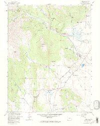
1957 Map of Como
USGS Topo · Published 1972About this map
Como serves as the focal point of this mid-century landscape, a town once defined by its role on the railroad before the tracks were replaced by the Old Railroad Grade. The survey reveals a region transitioning from its mining and industrial roots toward a ranching economy, with numerous named properties such as the Circle V Bar Eightmile Ranch, Bar D Ranch, and Red Hill Ranch scattered across the valleys. Higher elevations near Iron Mountain and Little Baldy Mountain show the lingering footprints of extraction, including the Silverheels Mine and Fortune Placer Mine.
Find a feature on this map
50 named features on this map. Tap any name to fly to it.
Don’t see what you’re looking for? This feature index may not catch every label — zoom into the map to look around manually.
Map Details
Editions of this 1957 Como Map
4 editions found
Other maps of this area

1889 · Leadville
USGS Topo · 1:125,000

1891 · Leadville
USGS Topo · 1:125,000

1934 · Climax
USGS Topo · 1:48,000

1937 · Como
USGS Topo · 1:62,500

1938 · Mt. Lincoln
USGS Topo · 1:48,000

1942 · Leadville
USGS Topo · 1:125,000

1945 · Mount Lincoln
USGS Topo · 1:62,500

1953 · Denver
USGS Topo · 1:250,000

1956 · Elkhorn
USGS Topo · 1:24,000

1956 · Fairplay East
USGS Topo · 1:24,000