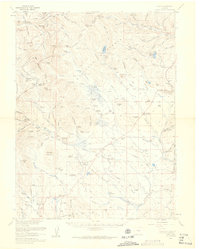
1958 Map of Como
USGS Topo · Published 1960About this map
The Continental Divide zigzags across this high-altitude landscape in the late 1950s, defining the drainage between the South Platte River and the Swan River Middle Fork. This era shows a transition from the area's mining and railroad heritage to an economy anchored by ranching and high-country recreation. Evidence of the mining boom is found at the Dyersville (Site) and scattered workings like The Carbonate Mine and the Gold Belt Corporal Mine.
Find a feature on this map
123 named features on this map. Tap any name to fly to it.
Don’t see what you’re looking for? This feature index may not catch every label — zoom into the map to look around manually.
Map Details
Editions of this 1958 Como Map
4 editions found
Other maps of this area

1889 · Leadville
USGS Topo · 1:125,000

1891 · Leadville
USGS Topo · 1:125,000

1903 · Georgetown
USGS Topo · 1:62,500

1905 · Georgetown
USGS Topo · 1:62,500

1924 · Montezuma
USGS Topo · 1:62,500

1926 · Montezuma
USGS Topo · 1:62,500

1929 · Dillon
USGS Topo · 1:62,500

1933 · Montezuma
USGS Topo · 1:62,500

1934 · Climax
USGS Topo · 1:48,000

1934 · Dillon
USGS Topo · 1:62,500