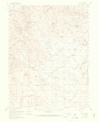
1958 Map of Como
USGS Topo · Published 1969About this map
The Continental Divide winds through this high-altitude landscape of Park and Summit Counties, marking the rugged boundary between the Arapaho National Forest and Pike National Forest. Following the mid-century mapping of the Missouri River Basin, the area shows a distinct transition from the early mining era to a cattle and ranching economy. Historic centers of activity like the settlement at Como and the Dyersville site are surrounded by evidence of former mineral wealth, including the Gold Bell Mine and King Cole Mine.
Find a feature on this map
140 named features on this map. Tap any name to fly to it.
Don’t see what you’re looking for? This feature index may not catch every label — zoom into the map to look around manually.
Map Details
Editions of this 1958 Como Map
4 editions found
Other maps of this area

1889 · Leadville
USGS Topo · 1:125,000

1891 · Leadville
USGS Topo · 1:125,000

1903 · Georgetown
USGS Topo · 1:62,500

1905 · Georgetown
USGS Topo · 1:62,500

1924 · Montezuma
USGS Topo · 1:62,500

1926 · Montezuma
USGS Topo · 1:62,500

1929 · Dillon
USGS Topo · 1:62,500

1933 · Montezuma
USGS Topo · 1:62,500

1934 · Climax
USGS Topo · 1:48,000

1934 · Dillon
USGS Topo · 1:62,500