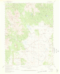
1958 Map of Como
USGS Topo · Published 1969About this map
Como and Jefferson anchor this late-1950s landscape, which illustrates a transition from 19th-century resource extraction to a mid-century ranching and recreation economy. The northwest corner is heavily marked by the region's mining heritage, specifically around Humbug Hill and Farncomb Hill, where the Lincoln Mine and Mineral Park Mine once operated. Traces of early mountain settlements appear as sites like Parkville and Dyersville, while several abandoned dwellings, including the Schattinger Homestead, reflect the difficulty of permanent residency in the high country.
Find a feature on this map
140 named features on this map. Tap any name to fly to it.
Don’t see what you’re looking for? This feature index may not catch every label — zoom into the map to look around manually.
Map Details
Editions of this 1958 Como Map
4 editions found
Other maps of this area

1889 · Leadville
USGS Topo · 1:125,000

1891 · Leadville
USGS Topo · 1:125,000

1903 · Georgetown
USGS Topo · 1:62,500

1905 · Georgetown
USGS Topo · 1:62,500

1924 · Montezuma
USGS Topo · 1:62,500

1926 · Montezuma
USGS Topo · 1:62,500

1929 · Dillon
USGS Topo · 1:62,500

1933 · Montezuma
USGS Topo · 1:62,500

1934 · Climax
USGS Topo · 1:48,000

1934 · Dillon
USGS Topo · 1:62,500