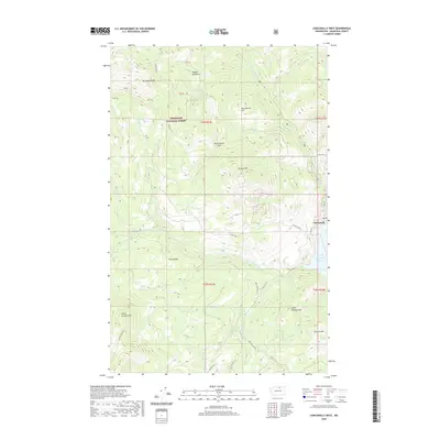
2020 Map of Conconully West
USGS Topo · Published 2020About this map
Conconully sits at the edge of the Conconully Reservoir, where the settlement serves as a gateway to the high peaks and drainages of the Okanogan National Forest. This 2020 topographic study illustrates the complex watershed formed by the N Fork Salmon Cr and W Fork Salmon Cr, which converge near the town site. The map documents the extensive network of Forest Service and county infrastructure, such as CO Hwy 2340 and Nat For Dev Rd 37, which navigate the steep ascents of Muckamuck Mtn and Peacock Mtn. A distinctive pattern of land management is visible in the private parcels and forest boundaries, particularly around Mineral Hill and Sophys Meadows. From the high elevations of Muckamuck Pass to the drops at Salmon Falls, the map traces the essential relationship between the region's managed timberlands and its vital water resources.
Find a feature on this map
45 named features on this map. Tap any name to fly to it.
Don’t see what you’re looking for? This feature index may not catch every label — zoom into the map to look around manually.
Map Details
Editions of this 2020 Conconully West Map
This is the sole edition of this map. No revisions or reprints were ever made.
Other maps of this area

1905 · Okanogan
USGS Topo · 1:125,000

1906 · Chopaka
USGS Topo · 1:125,000

1954 · Okanogan
USGS Topo · 1:250,000

1956 · Loup Loup
USGS Topo · 1:62,500

1956 · Tiffany Mountain
USGS Topo · 1:62,500

1957 · Okanogan
USGS Topo · 1:62,500

1957 · Conconully
USGS Topo · 1:62,500

1958 · Okanogan
USGS Topo · 1:250,000
1980 · Blue Goat Mtn
USGS Topo · 1:24,000
1980 · Ruby Hill
USGS Topo · 1:24,000