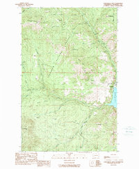
1989 Map of Conconully West
USGS Topo · Published 1989About this map
Sunny Peak Mine and the Wheeler Mine anchor a landscape of legacy hard-rock extraction along the eastern slopes of the Okanogan. During the late 1980s, this region near the town of Conconully remained a mix of public forest management and private ranching interests. Local families and history are tied to landholdings like Meyer Ranch and Reed Ranch, which sit amongst the complex drainage systems of the North Fork and South Fork Salmon Rivers. The map details the transition from the high elevations of Muckamuck Mountain and Peacock Mtn down to the recreational waters of Conconully Reservoir. Mining prospects and numerous tunnels are concentrated around Mineral Hill, reflecting the prospecting intensity that once defined this portion of the Okanogan National Forest.
Find a feature on this map
43 named features on this map. Tap any name to fly to it.
Don’t see what you’re looking for? This feature index may not catch every label — zoom into the map to look around manually.
Map Details
Editions of this 1989 Conconully West Map
This is the sole edition of this map. No revisions or reprints were ever made.
Other maps of this area

1905 · Okanogan
USGS Topo · 1:125,000

1906 · Chopaka
USGS Topo · 1:125,000

1954 · Okanogan
USGS Topo · 1:250,000

1956 · Loup Loup
USGS Topo · 1:62,500

1956 · Tiffany Mountain
USGS Topo · 1:62,500

1957 · Okanogan
USGS Topo · 1:62,500

1957 · Conconully
USGS Topo · 1:62,500

1958 · Okanogan
USGS Topo · 1:250,000
1980 · Blue Goat Mtn
USGS Topo · 1:24,000
1980 · Ruby Hill
USGS Topo · 1:24,000