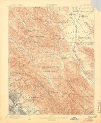
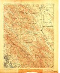
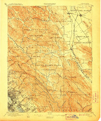
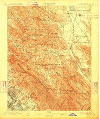
1897 Map of Concord
USGS Topo · Published 1905About this map
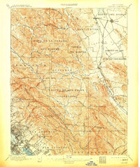
The eastern foothills of the East Bay appear in a period of transition, defined by large Spanish land grant boundaries and a growing railroad network. The Southern Pacific RR and San Ramon Valley RR facilitate the movement of goods through the San Ramon Valley, connecting established settlements like Concord and Walnut Creek to the urbanizing edges of the East Bay shoreline. Large ranchos such as Laguna De Los Palos Colorados and San Antonio Y Peralta still dominate the landscape, their Spanish-era boundaries intersecting with modern surveying lines.
Find a feature on this map
100 named features on this map. Tap any name to fly to it.
Don’t see what you’re looking for? This feature index may not catch every label — zoom into the map to look around manually.
Map Details
Editions of this 1897 Concord Map
6 editions found
Other maps of this area

1892 · San Mateo
USGS Topo · 1:62,500

1895 · San Francisco
USGS Topo · 1:62,500

1896 · San Mateo
USGS Topo · 1:62,500

1896 · Carquinez Strait
USGS Topo · 1:62,500

1896 · Mt. Diablo
USGS Topo · 1:62,500

1897 · Concord
USGS Topo · 1:62,500

1898 · Karquines
USGS Topo · 1:62,500

1898 · Mt. Diablo
USGS Topo · 1:62,500

1899 · San Francisco
USGS Topo · 1:62,500

1899 · Haywards
USGS Topo · 1:62,500