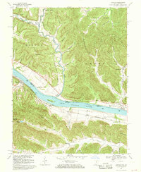
1967 Map of Concord
USGS Topo · Published 1969About this map
The Ohio River divides the landscape of this 1960s survey, marking the border between Adams Co, Ohio, and Lewis Co, Kentucky. On the southern bank, the Chesapeake and Ohio railroad corridor anchors small riverside stops like Rome Station and Chalkley Station near the village of Concord. This transportation artery facilitated the transport of timber and agriculture from the interior valleys, where family-named hollows like Mefford Hol and Bruce Hol suggest a long history of local settlement. North of the river, the terrain rises into the Shawnee State Forest, with isolated communities such as Squirrel Town and Stout situated along the shoreline. Rural social centers are well-documented through features like the Beasley Fork Chapel, Green Sch, and Munea Chapel, reflecting the distributed nature of river-bottom and ridge-top farming communities during this era.
Find a feature on this map
77 named features on this map. Tap any name to fly to it.
Don’t see what you’re looking for? This feature index may not catch every label — zoom into the map to look around manually.
Map Details
Editions of this 1967 Concord Map
3 editions found
Other maps of this area

1916 · Peebles
USGS Topo · 1:62,500

1918 · Peebles
USGS Topo · 1:62,500

1918 · Seaman
USGS Topo · 1:62,500

1919 · Vanceburg
USGS Topo · 1:62,500

1929 · Springdale
USGS Topo · 1:48,000

1935 · Springdale
USGS Topo · 1:62,500

1949 · Vanceburg
USGS Topo · 1:62,500

1949 · Buena Vista
USGS Topo · 1:24,000

1949 · Vanceburg
USGS Topo · 1:24,000

1949 · Concord
USGS Topo · 1:24,000