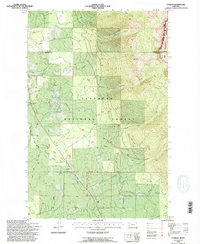
1994 Map of Condon
USGS Topo · Published 1996About this map
Condon serves as the central hub of this mid-1990s mountain landscape, which is heavily defined by the boundaries of the Flathead National Forest. The settlement includes the Condon PO and the Condon Forest Service Station, highlighting its role as a base for forest management and local services. The Swan River flows through the valley, flanked by Smith Flats and an adjacent Landing Strip, suggesting a reliance on light aircraft for transport and access in this high-elevation terrain. To the east, the topography rises sharply toward the Bob Marshall Wilderness, where numerous drainages like Condon Creek and McKay Creek feed into the river system. The presence of the Cooney Lookout overlooking Cooney Creek underscores the ongoing importance of fire observation and wilderness stewardship in this densely forested region.
Find a feature on this map
24 named features on this map. Tap any name to fly to it.
Don’t see what you’re looking for? This feature index may not catch every label — zoom into the map to look around manually.
Map Details
Editions of this 1994 Condon Map
This is the sole edition of this map. No revisions or reprints were ever made.
Other maps of this area

1921 · Elbow Lake
USGS Topo · 1:125,000

1955 · Choteau
USGS Topo · 1:250,000

1957 · Choteau
USGS Topo · 1:250,000

1958 · Choteau
USGS Topo · 1:250,000

1962 · Choteau
USGS Topo · 1:250,000

1965 · Peck Lake
USGS Topo · 1:24,000

1965 · Condon
USGS Topo · 1:24,000

1965 · Sunburst Lake
USGS Topo · 1:24,000

1965 · Holland Lake
USGS Topo · 1:24,000

1965 · Swan Peak
USGS Topo · 1:24,000