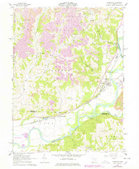
1962 Map of Conesville
USGS Topo · Published 1978About this map
The Muskingum River and Wills Creek define the southern and eastern landscape of this area, where the river valley once served as a major transportation corridor. The map illustrates a complex network of rail infrastructure, including the Pennsylvania and New York Chicago and St Louis line crossing through Conesville and Adams Mills. This era of the 1960s, revised in the late 1970s, shows a landscape being actively reshaped by energy extraction, with extensive Strip Mines and several Strip Mine operations concentrated in the northern hills between New Moscow and Tyndall. Local social and religious history is well-documented through numerous rural landmarks such as Christian Chapel, Warner Ch, and Grange Hall. A notable industrial detail is the large Substation near Conesville, connected to the nearby water and rail assets, and a significant Reclaimed Area indicating early environmental restoration efforts following surface mining.
Find a feature on this map
39 named features on this map. Tap any name to fly to it.
Don’t see what you’re looking for? This feature index may not catch every label — zoom into the map to look around manually.
Map Details
Editions of this 1962 Conesville Map
4 editions found
Other maps of this area

1908 · Conesville
USGS Topo · 1:62,500

1910 · Frazeysburg
USGS Topo · 1:62,500

1910 · Conesville
USGS Topo · 1:62,500

1913 · Brinkhaven
USGS Topo · 1:62,500

1913 · Coshocton
USGS Topo · 1:62,500

1915 · Brinkhaven
USGS Topo · 1:62,500

1915 · Coshocton
USGS Topo · 1:62,500

1943 · Coshocton
USGS Topo · 1:62,500

1950 · Marion
USGS Topo · 1:250,000

1951 · Canton
USGS Topo · 1:250,000