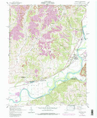
1962 Map of Conesville
USGS Topo · Published 1987About this map
New Moscow and Conesville anchor this 1960s study of the Muskingum River valley, where the landscape is defined by the heavy footprint of the regional extraction industry. Extensive Strip Mines and a large Reclaimed Area dominate the ridges surrounding Davis Hollow and Barnes Hollow, contrasting with the wetlands of the Monroe Basin State Wildlife Area. The transport network reveals layers of transit history, from the path of the Abandoned Canal running parallel to the Muskingum River to the active rail lines of Conrail and the Norfolk and Western. Local genealogy is well-preserved through numerous family and community landmarks, including the Warner Ch Cem, McGee Cem, and Titus Cem. Along the southern border, the village of Adams Mills sits at a critical junction where Wills Creek meets the river, illustrating the historical reliance on these waterways for both power and transport.
Find a feature on this map
42 named features on this map. Tap any name to fly to it.
Don’t see what you’re looking for? This feature index may not catch every label — zoom into the map to look around manually.
Map Details
Editions of this 1962 Conesville Map
4 editions found
Other maps of this area

1908 · Conesville
USGS Topo · 1:62,500

1910 · Frazeysburg
USGS Topo · 1:62,500

1910 · Conesville
USGS Topo · 1:62,500

1913 · Brinkhaven
USGS Topo · 1:62,500

1913 · Coshocton
USGS Topo · 1:62,500

1915 · Brinkhaven
USGS Topo · 1:62,500

1915 · Coshocton
USGS Topo · 1:62,500

1943 · Coshocton
USGS Topo · 1:62,500

1950 · Marion
USGS Topo · 1:250,000

1951 · Canton
USGS Topo · 1:250,000