
1983 Map of Connell
USGS Topo · Published 1983About this map
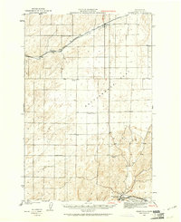
Connell serves as a central hub in this high-desert landscape, where the agricultural corridors of the Washtucna Coulee and Esquatzel Coulee meet the iron rails of the Burlington Northern and Union Pacific railroads. The map documents a complex network of dry coulees and named prairies, including Kansas Prairie and Michigan Prairie, which define the terrain of the Columbia Basin. To the southeast, the geography shifts dramatically at the Snake River, where the Lower Monumental Dam has created Lake Herbert G West. This 1980s-era survey captures the transition from small rail-side settlements like Hatton and Benge to the monumental engineering of the river's dams and the iconic Palouse Falls, illustrating how water management and rail transportation shaped Eastern Washington's development.
Find a feature on this map
73 named features on this map. Tap any name to fly to it.
Don’t see what you’re looking for? This feature index may not catch every label — zoom into the map to look around manually.
Map Details
Editions of this 1983 Connell Map
This is the sole edition of this map. No revisions or reprints were ever made.
Other maps of this area

1915 · Wallulah
USGS Topo · 1:96,000

1916 · Connell
USGS Topo · 1:125,000

1917 · Pasco
USGS Topo · 1:125,000

1918 · Connell
USGS Topo · 1:125,000

1918 · Wallula
USGS Topo · 1:125,000

1919 · Walla Walla
USGS Topo · 1:125,000

1921 · Walla Walla
USGS Topo · 1:125,000
1923 · Washtucna
USGS Topo · 1:62,500

1923 · Wheeler
USGS Topo · 1:62,500

1924 · Othello
USGS Topo · 1:62,500