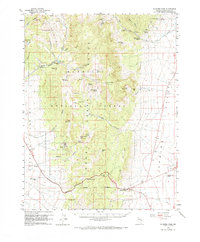
1959 Map of Connors Pass
USGS Topo · Published 1970About this map
The Shell Creek Range divides this high-altitude landscape of White Pine County, rising between the Steptoe Valley to the west and Spring Valley to the east. Historically centered on the Taylor (Site) mining district, the area shows the transition from late-19th-century boom years to mid-20th-century recreation and transit. A cemetery remains near the Taylor settlement site, while the rugged interior of the Humboldt National Forest is dotted with numerous water sources like Crethers Springs and Bastian Spr, vital for both livestock and the local ecosystem.
Find a feature on this map
54 named features on this map. Tap any name to fly to it.
Don’t see what you’re looking for? This feature index may not catch every label — zoom into the map to look around manually.
Map Details
Editions of this 1959 Connors Pass Map
2 editions found

Other maps of this area

1948 · Wheeler Peak
USGS Topo · 1:62,500

1950 · Wheeler Peak
USGS Topo · 1:62,500

1952 · Ely
USGS Topo · 1:125,000

1956 · Lund
USGS Topo · 1:250,000

1956 · Ely
USGS Topo · 1:250,000

1958 · East Ely
USGS Topo · 1:24,000

1958 · Comins Lake
USGS Topo · 1:24,000

1958 · Ely
USGS Topo · 1:62,500

1958 · McGill
USGS Topo · 1:62,500

1959 · Ely
USGS Topo · 1:250,000