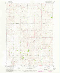
1960 Map of Conrad West
USGS Topo · Published 1980About this map
Agricultural life in central Iowa's Grundy and Marshall counties is clearly documented in this mid-century survey. The landscape is defined by the drainage patterns of Wolf Creek in the north and the winding course of Asher Creek and Little Asher Creek further south. A notable remnant of earlier transportation infrastructure appears as an Old Railroad Grade cutting across the northern portion of the map, suggesting the evolution of the local transit network. Near the town of Conrad, a prominent Quarry indicates the area's local extraction industry.
Find a feature on this map
16 named features on this map. Tap any name to fly to it.
Don’t see what you’re looking for? This feature index may not catch every label — zoom into the map to look around manually.
Map Details
Editions of this 1960 Conrad West Map
2 editions found
Other maps of this area

1954 · Waterloo
USGS Topo · 1:250,000

1955 · Waterloo
USGS Topo · 1:250,000

1960 · Marshalltown
USGS Topo · 1:24,000

1960 · Marshalltown
USGS Topo · 1:62,500

1960 · Le Grand
USGS Topo · 1:24,000

1960 · Conrad West
USGS Topo · 1:24,000

1960 · Conrad East
USGS Topo · 1:24,000

1975 · Union
USGS Topo · 1:24,000
1975 · La Moille
USGS Topo · 1:24,000

1979 · Grundy Center
USGS Topo · 1:24,000