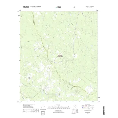
2019 Map of Conroe NE
USGS Topo · Published 2019About this map
The Sam Houston National Forest dominates the landscape of this East Texas terrain, where the boundary between San Jacinto and Montgomery counties winds through a dense network of creek bottoms and forested ridges. This 2019 survey captures a rural environment defined by its watercourses, including the southward-flowing Caney Creek and its many tributaries like Turkey Creek and Boggy Creek. While large tracts are preserved within the national forest, the southern portion of the map shows increasing residential development along roads like FM 1484 Road and E Williams Road. Local history is preserved at the Hickory Grove Cemetery, while the Outlaw Flyers Airport and the distinct terrain of Steep Hollow provide clear landmarks for modern navigation and genealogical research in this wooded corner of the Piney Woods.
Find a feature on this map
53 named features on this map. Tap any name to fly to it.
Don’t see what you’re looking for? This feature index may not catch every label — zoom into the map to look around manually.
Map Details
Editions of this 2019 Conroe NE Map
This is the sole edition of this map. No revisions or reprints were ever made.
Other maps of this area

1954 · Beaumont
USGS Topo · 1:250,000

1957 · Beaumont
USGS Topo · 1:250,000

1958 · Conroe
USGS Topo · 1:24,000

1958 · Fostoria
USGS Topo · 1:24,000

1958 · Bear Creek
USGS Topo · 1:24,000

1959 · Cut and Shoot
USGS Topo · 1:24,000

1959 · Conroe NE
USGS Topo · 1:24,000

1960 · Willis
USGS Topo · 1:24,000

1960 · Maynard
USGS Topo · 1:24,000

1960 · New Waverly
USGS Topo · 1:24,000