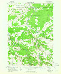
1964 Map of Constable
USGS Topo · Published 1966About this map
The Canada United States border defines the northern limit of this northern Franklin County landscape, where the US Customs Port of Entry at Trout River marks the transition between New York and Quebec. The village of Constable serves as a local hub, situated near the confluence of the Trout River and Little Trout River. Religious and genealogical history is anchored by the St Francis of Assisi Cem, Methodist Cem, and the Church of Our Lady of Fatima located further west near the Salmon River.
Find a feature on this map
57 named features on this map. Tap any name to fly to it.
Don’t see what you’re looking for? This feature index may not catch every label — zoom into the map to look around manually.
Map Details
Editions of this 1964 Constable Map
2 editions found
Other maps of this area

1915 · Chateaugay
USGS Topo · 1:62,500

1915 · Malone
USGS Topo · 1:62,500

1917 · Malone
USGS Topo · 1:62,500

1943 · Chateaugay
USGS Topo · 1:62,500

1948 · Ogdensburg
USGS Topo · 1:250,000

1951 · Ogdensburg
USGS Topo · 1:250,000

1953 · Ogdensburg
USGS Topo · 1:250,000

1961 · Ogdensburg
USGS Topo · 1:250,000
1964 · Ft. Covington
USGS Topo · 1:24,000
1964 · Burke
USGS Topo · 1:24,000