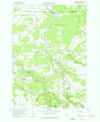
1964 Map of Constable
USGS Topo · Published 1976About this map
The international boundary between Canada and the United States defines the northern edge of this northern New York landscape, marked by a U S Customs Port of Entry where the Trout River crosses the border. The settlement of Constable serves as a local hub, situated near the confluence of the river and several rural routes. The map reveals a community structured around its spiritual and memorial sites, including the St Francis of Assisi Cem and the nearby Methodist Cem.
Find a feature on this map
59 named features on this map. Tap any name to fly to it.
Don’t see what you’re looking for? This feature index may not catch every label — zoom into the map to look around manually.
Map Details
Editions of this 1964 Constable Map
2 editions found
Other maps of this area

1915 · Chateaugay
USGS Topo · 1:62,500

1915 · Malone
USGS Topo · 1:62,500

1917 · Malone
USGS Topo · 1:62,500

1943 · Chateaugay
USGS Topo · 1:62,500

1948 · Ogdensburg
USGS Topo · 1:250,000

1951 · Ogdensburg
USGS Topo · 1:250,000

1953 · Ogdensburg
USGS Topo · 1:250,000

1961 · Ogdensburg
USGS Topo · 1:250,000
1964 · Ft. Covington
USGS Topo · 1:24,000
1964 · Burke
USGS Topo · 1:24,000