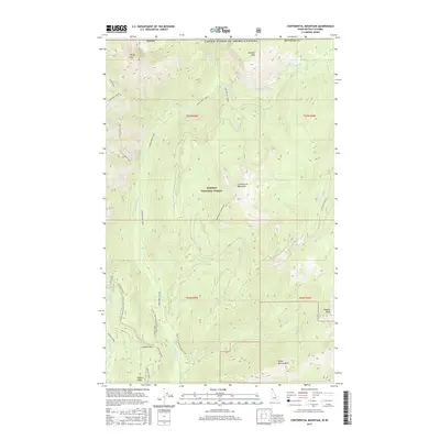
2017 Map of Continental Mountain
USGS Topo · Published 2017About this map
Kaniksu National Forest defines this high-elevation landscape along the international border, where the United States and Canada meet. The geography is dominated by the northern reaches of the Upper Priest River, which flows past landmarks like Upper Priest Falls and through the Salmo Basin. This terrain is characterized by sharp ridgelines such as the Shedroof Divide and Hughes Ridge, forming a complex drainage network for Continental Creek and Cedar Cr. Hikers and conservationists can trace the high-altitude route of the Pacific NW National Scenic Trail as it traverses the western side of the quadrangle near Cabinet Pass. High peaks including Snowy Top, Continental Mountain, and Green Bonnet Mtn provide significant vertical relief, while isolated water bodies like Continental Lake and Trap Lake occupy high basins.
Find a feature on this map
36 named features on this map. Tap any name to fly to it.
Don’t see what you’re looking for? This feature index may not catch every label — zoom into the map to look around manually.
Map Details
Editions of this 2017 Continental Mountain Map
This is the sole edition of this map. No revisions or reprints were ever made.
Other maps of this area

1911 · Priest Lake
USGS Topo · 1:250,000

1913 · Priest Lake
USGS Topo · 1:250,000

1934 · Metaline
USGS Topo · 1:125,000

1942 · Metaline
USGS Topo · 1:125,000

1958 · Sandpoint
USGS Topo · 1:250,000

1963 · Sandpoint
USGS Topo · 1:250,000

1967 · Salmo Mtn.
USGS Topo · 1:24,000

1967 · Helmer Mtn
USGS Topo · 1:24,000
1968 · Continental Mtn
USGS Topo · 1:24,000

1969 · Grass Mountain
USGS Topo · 1:24,000