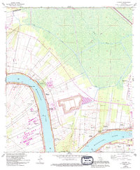
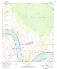
1962 Map of Convent
USGS Topo · Published 1994About this map
Plantation landscapes and riverfront settlements dominate this reach of the Mississippi River in the early 1960s. The map illustrates a dense concentration of historical riverside estates, including the iconic Oak Alley Plantation, St Joseph Plantation, and Uncle Sam Plantation. These properties are clustered along the high ground of the river's natural levees, where agricultural activity meets industrial development like the Hestor Oil and Gas Field. Small communities such as Chatman Town, Romeville, and Welcome sit alongside long-established landmarks like College Point and the St Michael Ch and school. The geography is defined by the sharp contrast between the organized linear land divisions of the riverfront and the expansive wetlands to the north, which are drained by the Blind River and the Bayou des Acadiens.
Find a feature on this map
42 named features on this map. Tap any name to fly to it.
Don’t see what you’re looking for? This feature index may not catch every label — zoom into the map to look around manually.
Map Details
Editions of this 1962 Convent Map
5 editions found
Other maps of this area

1892 · Lac Des Allemands
USGS Topo · 1:62,500

1892 · Mount Airy
USGS Topo · 1:62,500

1892 · Donaldsonville
USGS Topo · 1:62,500

1892 · Thibodaux
USGS Topo · 1:62,500

1927 · Thibodaux NW
USGS Topo · 1:31,680

1932 · Lac Des Allemands NW
USGS Topo · 1:31,680

1932 · Thibodaux NE
USGS Topo · 1:31,680

1935 · Gonzales
USGS Topo · 1:31,680

1939 · Donaldsonville
USGS Topo · 1:62,500

1940 · Lagan
USGS Topo · 1:31,680