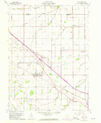
1960 Map of Convoy
USGS Topo · Published 1972About this map
The village of Convoy serves as the central hub for this rural portion of Van Wert County, where the Penn Central railroad cuts diagonally across a landscape dominated by agriculture and systematic road grids. This 1960 survey, later updated with 1971 aerial data, reveals a community deeply rooted in its local institutions, including numerous country churches such as Sugar Ridge Ch, Asbury Ch, and Pleasant Chapel. The importance of education is evidenced by the Convoy Union Jr High Sch and St Johns Sch. Beyond the village limits, the terrain is drained by a complex network of waterways including Blue Creek, Pottawatomie Cr, and Monkey Run. This map captures the transition from traditional small-town life to the late 20th century, where industry like Union Quarries sits alongside long-established landmarks like the Township Cem.
Find a feature on this map
58 named features on this map. Tap any name to fly to it.
Don’t see what you’re looking for? This feature index may not catch every label — zoom into the map to look around manually.
Map Details
Editions of this 1960 Convoy Map
3 editions found
Other maps of this area

1914 · Van Wert
USGS Topo · 1:62,500

1914 · Paulding
USGS Topo · 1:62,500

1944 · Van Wert
USGS Topo · 1:62,500

1944 · Paulding
USGS Topo · 1:62,500

1953 · Fort Wayne
USGS Topo · 1:250,000

1953 · Muncie
USGS Topo · 1:250,000

1956 · Muncie
USGS Topo · 1:250,000

1956 · Fort Wayne
USGS Topo · 1:250,000

1958 · Woodburn South
USGS Topo · 1:24,000
1960 · Convoy
USGS Topo · 1:24,000