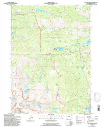
1991 Map of Cony Mountain
USGS Topo · Published 1997About this map
Cony Mountain stands as a central peak in a landscape defined by high-altitude meadows and glacier-fed waters within the Shoshone National Forest. This 1991 survey illustrates the transition from managed forest lands to the protected alpine terrain of the Popo Agie Wilderness, where Popo Agie Mountain and Atlantic Canyon dominate the southern reaches. The map documents a complex hydrological system of natural lakes and reservoirs, including Worthen Meadow Reservoir and Leg Lake, which feed the various forks of the Popo Agie.
Find a feature on this map
45 named features on this map. Tap any name to fly to it.
Don’t see what you’re looking for? This feature index may not catch every label — zoom into the map to look around manually.
Map Details
Editions of this 1991 Cony Mountain Map
2 editions found
Other maps of this area

1937 · Moccasin Lake
USGS Topo · 1:48,000

1943 · Moccasin Lake
USGS Topo · 1:62,500

1953 · Sweetwater Gap
USGS Topo · 1:24,000

1953 · Cony Mountain
USGS Topo · 1:24,000

1953 · Mount Arter
USGS Topo · 1:24,000

1953 · Fossil Hill
USGS Topo · 1:24,000

1953 · Louis Lake
USGS Topo · 1:24,000

1953 · Christina Lake
USGS Topo · 1:24,000

1953 · Mount Arter SE
USGS Topo · 1:24,000

1955 · Lander
USGS Topo · 1:250,000