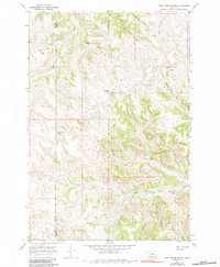
1967 Map of Cook Creek Butte
USGS Topo · Published 1984About this map
The Northern Cheyenne Indian Reservation covers much of this high plains landscape, spanning the boundary between Big Horn and Rosebud counties. The terrain is defined by a complex network of ephemeral drainage systems and springs that feed into major watercourses like Muddy Creek and Cook Creek. Notable cultural and topographical landmarks include the Buffalo Jump located near the center of the sheet and the prominent Cook Creek Butte to the west. This 1967 field check documents a rural environment where land use is dictated by the deeply eroded coulees, such as Longjaw Coulee, and the various forks of the local creek systems, including Black Eagle Fork Cook Creek and St Johns Creek. The map provides a detailed view of the natural water sources critical to this region, marking numerous unnamed springs that dot the hillsides between Wild Hog Creek and Paddy Creek.
Find a feature on this map
15 named features on this map. Tap any name to fly to it.
Don’t see what you’re looking for? This feature index may not catch every label — zoom into the map to look around manually.
Map Details
Editions of this 1967 Cook Creek Butte Map
2 editions found
Other maps of this area

1954 · Hardin
USGS Topo · 1:250,000

1957 · Hardin
USGS Topo · 1:250,000

1958 · Hardin
USGS Topo · 1:250,000

1958 · Painted Hill
USGS Topo · 1:24,000

1958 · Bull Creek Lookout
USGS Topo · 1:24,000

1958 · Fisher Butte
USGS Topo · 1:24,000

1958 · Lame Deer
USGS Topo · 1:24,000

1967 · Clubfoot Creek
USGS Topo · 1:24,000

1967 · Birney
USGS Topo · 1:24,000
1967 · Cook Creek Butte
USGS Topo · 1:24,000