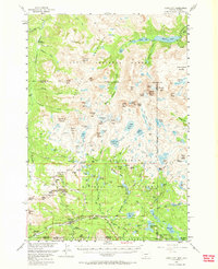
1956 Map of Cooke City
USGS Topo · Published 1968About this map
High-altitude mining operations define the landscape surrounding Cooke City in the mid-1950s, where the extraction of precious metals has left a distinct mark on the Beartooth Mountains. Numerous workings like the Glengarry Mines, Irma Mines, and the Bull of the Woods Mine are clustered near the Montana-Wyoming border, signaling the area's long reliance on hard-rock mining. The topography is dominated by massive peaks and glacial features, including the state's highest point at Granite Peak and the sprawling Granite Glacier.
Find a feature on this map
130 named features on this map. Tap any name to fly to it.
Don’t see what you’re looking for? This feature index may not catch every label — zoom into the map to look around manually.
Map Details
Editions of this 1956 Cooke City Map
5 editions found

Other maps of this area

1886 · Canyon
USGS Topo · 1:125,000

1891 · Livingston
USGS Topo · 1:250,000

1893 · Livingston
USGS Topo · 1:250,000

1895 · Canyon
USGS Topo · 1:125,000

1896 · Canyon
USGS Topo · 1:125,000

1896 · Crandall Creek
USGS Topo · 1:125,000

1898 · Granite Mountain District
USGS Topo · 1:125,000

1899 · Crandall
USGS Topo · 1:125,000

1901 · Canyon
USGS Topo · 1:125,000

1907 · Canyon
USGS Topo · 1:125,000