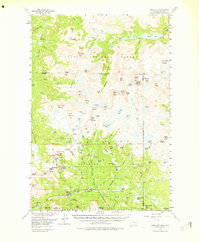
1956 Map of Cooke City
USGS Topo · Published 1975About this map
Cooke City serves as the focal point for this mid-century survey of the high mountain borderlands between Montana and Wyoming. The landscape is defined by the convergence of the Custer National Forest, Gallatin National Forest, and Shoshone National Forest, reflecting a region managed for both its natural resources and wilderness. Mining activity is densely concentrated south of the townsite, where the extraction history of the Beartooth Mountains is evidenced by several named operations, including the Glengarry Mines, Gold Dust Mines, and the Black Warrior Mine.
Find a feature on this map
136 named features on this map. Tap any name to fly to it.
Don’t see what you’re looking for? This feature index may not catch every label — zoom into the map to look around manually.
Map Details
Editions of this 1956 Cooke City Map
5 editions found

Other maps of this area

1886 · Canyon
USGS Topo · 1:125,000

1891 · Livingston
USGS Topo · 1:250,000

1893 · Livingston
USGS Topo · 1:250,000

1895 · Canyon
USGS Topo · 1:125,000

1896 · Canyon
USGS Topo · 1:125,000

1896 · Crandall Creek
USGS Topo · 1:125,000

1898 · Granite Mountain District
USGS Topo · 1:125,000

1899 · Crandall
USGS Topo · 1:125,000

1901 · Canyon
USGS Topo · 1:125,000

1907 · Canyon
USGS Topo · 1:125,000