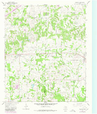
1965 Map of Cookville
USGS Topo · Published 1980About this map
The boundary between Titus Co and Morris Co defines the center of this rural landscape, which was primarily focused on agriculture and timber in the mid-1960s. The St Louis Southwestern railroad serves as the primary East-West corridor, connecting the settlements of Cookville and Omaha. These small communities, along with Lone Star to the north and Center Grove to the south, are anchored by numerous country churches and family burial grounds like Mt Moriah Ch, Kirby Cem, and Barrier Cem.
Find a feature on this map
30 named features on this map. Tap any name to fly to it.
Don’t see what you’re looking for? This feature index may not catch every label — zoom into the map to look around manually.
Map Details
Editions of this 1965 Cookville Map
2 editions found
Other maps of this area

1914 · Daingerfield
USGS Topo · 1:62,500

1930 · Bassett
USGS Topo · 1:62,500

1953 · Texarkana
USGS Topo · 1:250,000

1956 · Texarkana
USGS Topo · 1:250,000

1964 · Harvard
USGS Topo · 1:24,000

1964 · Wilkinson
USGS Topo · 1:24,000

1964 · Daingerfield
USGS Topo · 1:24,000

1964 · Cason
USGS Topo · 1:24,000

1965 · Dalby Springs
USGS Topo · 1:24,000

1965 · Mount Pleasant
USGS Topo · 1:24,000