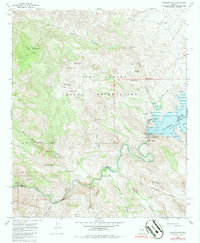
1968 Map of Coolidge Dam
USGS Topo · Published 1986About this map
Soda Canyon carves a path through the landscape of the San Carlos Indian Reservation in Gila County, Arizona, during the late 1960s. This drainage system reveals the complex geological and hydrological patterns of the region, where seasonal water flow and structural landforms define the territory. The survey, conducted shortly after the mid-century, captures the topography of this high-desert environment before subsequent decades of environmental shift and land use changes. The absence of dense infrastructure highlights a period when natural landforms like canyons and washes were the primary landmarks for navigation and land management across this portion of the reservation.
Find a feature on this map
1 named feature on this map. Tap any name to fly to it.
Don’t see what you’re looking for? This feature index may not catch every label — zoom into the map to look around manually.
Map Details
Editions of this 1968 Coolidge Dam Map
2 editions found
Other maps of this area

1915 · Christmas
USGS Topo · 1:62,500

1917 · Christmas
USGS Topo · 1:62,500

1954 · Mesa
USGS Topo · 1:250,000

1957 · Mesa
USGS Topo · 1:250,000

1958 · Mesa
USGS Topo · 1:250,000

1960 · Mesa
USGS Topo · 1:250,000

1962 · San Carlos Reservoir
USGS Topo · 1:62,500

1964 · Mesa
USGS Topo · 1:250,000

1965 · Bucket Mtn
USGS Topo · 1:24,000
1966 · San Carlos
USGS Topo · 1:24,000