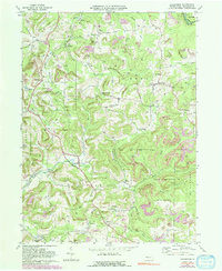
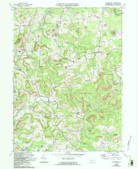
1969 Map of Coolspring
USGS Topo · Published 1992About this map
The hills and creek valleys of Jefferson County are marked by a deep-rooted industrial and religious landscape in this 1969 field-checked survey. Numerous Gas Wells and active Strip Mine operations are peppered throughout the townships of Rose, Knox, and Oliver, illustrating the region's reliance on mineral and fuel extraction. The Pittsburg and Shawmut railroad snakes through the terrain, connecting small coal and timber settlements like Ramsaytown and Knox Dale to the wider Pennsylvania rail network, alongside lines of the Conrail system.
Find a feature on this map
58 named features on this map. Tap any name to fly to it.
Don’t see what you’re looking for? This feature index may not catch every label — zoom into the map to look around manually.
Map Details
Editions of this 1969 Coolspring Map
5 editions found
Other maps of this area

1906 · Punxsutawney
USGS Topo · 1:62,500

1909 · Smicksburg
USGS Topo · 1:62,500

1922 · Du Bois
USGS Topo · 1:62,500

1924 · Du Bois
USGS Topo · 1:62,500

1924 · Brookville
USGS Topo · 1:62,500

1926 · Brookville
USGS Topo · 1:62,500

1938 · Smicksburg
USGS Topo · 1:62,500

1939 · Smicksburg
USGS Topo · 1:62,500

1939 · Punxsutawney
USGS Topo · 1:62,500

1942 · Punxsutawney
USGS Topo · 1:62,500
Featured Places
- Pine Creek Township, PA
- Knox Township, PA
- Rose Township, PA
- Sprankle Mills, Oliver Township
- Oliver Township, PA