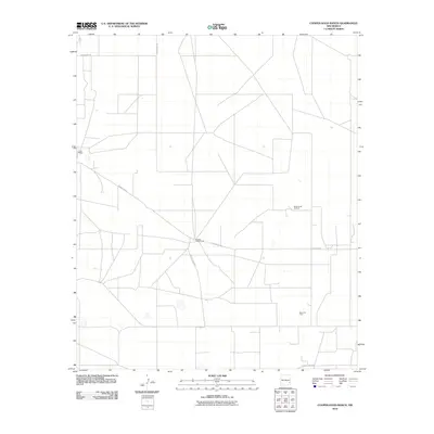
2010 Map of Cooper-Good Ranch
USGS Topo · Published 2010About this map
Cooper-Good Ranch and Price Ranch anchor this high plains landscape in eastern Lea County, reflecting the deep-rooted cattle ranching traditions of the Llano Estacado. The geometric grid of the survey is overlaid by a network of ranch roads and specialized petroleum infrastructure, most notably the Baum Oil Field and Baum North Oil Field. These energy developments illustrate the dual-economic nature of the region during the early twenty-first century, where traditional land use coexists with intensive mineral extraction. Local transportation is defined by rural arteries such as County Rd-159 and County Rd-108A, which provide the primary access to these isolated ranching and industrial sites across the open terrain.
Find a feature on this map
7 named features on this map. Tap any name to fly to it.
Don’t see what you’re looking for? This feature index may not catch every label — zoom into the map to look around manually.
Map Details
Editions of this 2010 Cooper-Good Ranch Map
This is the sole edition of this map. No revisions or reprints were ever made.
Other maps of this area

1954 · Brownfield
USGS Topo · 1:250,000

1958 · Brownfield
USGS Topo · 1:250,000

1962 · Brownfield
USGS Topo · 1:250,000

1973 · Mescalero Point
USGS Topo · 1:24,000

1973 · Fort Ranch
USGS Topo · 1:24,000

1973 · Soldier Hill
USGS Topo · 1:24,000

1973 · Caudill Ranch
USGS Topo · 1:24,000

1973 · Cooper-Good Ranch
USGS Topo · 1:24,000

1973 · Dean Ranch
USGS Topo · 1:24,000
1973 · Cedar Point SE
USGS Topo · 1:24,000