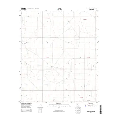
2013 Map of Cooper-Good Ranch
USGS Topo · Published 2013About this map
Cooper-Good Ranch and Price Ranch anchor this high plains landscape in eastern Lea County, characterizing the ranching roots of the region. The landscape is defined by the significant development of petroleum resources, with the extensive Caprock Oil Field occupying the northwest and the Baum North Oil Field, Baum Oil Field, and Lazy J Oil Field distributed across the eastern sections. These industrial features contrast with the sparse network of rural routes such as Co Road 159 and Good Rd. The grid-based settlement pattern is typical of the Llano Estacado, where large ranch holdings and energy extraction coincide. This 2013 survey provides a clear look at the intersection of traditional land use and the modern oil economy, showing how service roads like Prisciilla Rd and Co Road 108A provide access to remote well sites and homesteads.
Find a feature on this map
18 named features on this map. Tap any name to fly to it.
Don’t see what you’re looking for? This feature index may not catch every label — zoom into the map to look around manually.
Map Details
Editions of this 2013 Cooper-Good Ranch Map
This is the sole edition of this map. No revisions or reprints were ever made.
Other maps of this area

1954 · Brownfield
USGS Topo · 1:250,000

1958 · Brownfield
USGS Topo · 1:250,000

1962 · Brownfield
USGS Topo · 1:250,000

1973 · Mescalero Point
USGS Topo · 1:24,000

1973 · Fort Ranch
USGS Topo · 1:24,000

1973 · Soldier Hill
USGS Topo · 1:24,000

1973 · Caudill Ranch
USGS Topo · 1:24,000

1973 · Cooper-Good Ranch
USGS Topo · 1:24,000

1973 · Dean Ranch
USGS Topo · 1:24,000
1973 · Cedar Point SE
USGS Topo · 1:24,000