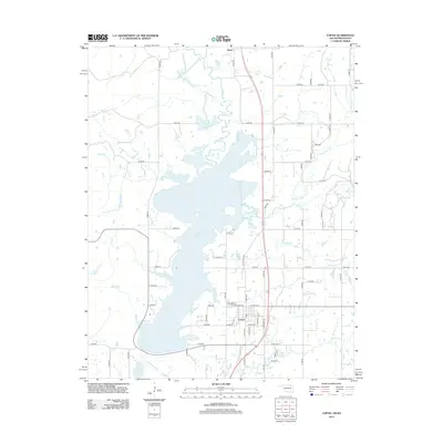
2013 Map of Copan
USGS Topo · Published 2013About this map
Copan Lake dominates this northern Oklahoma landscape, its sprawling waters flooding the valley where the Little Caney River meets Mud Cr. The town of Copan sits at the southern edge of the reservoir, positioned along the corridor of the Old Caney Hwy and modern highway routes. To the north, the small settlement of Owen remains a distinct point on the map near the Kansas border. The surrounding terrain is defined by a network of drainage creeks including Pooler Cr, Cotton Cr, and Brush Cr, which feed into the primary river system. This 2013 survey illustrates the modern configuration of the reservoir and the rural road grid, such as N 3970 Rd and E0030 Rd, that connects the remaining uplands and lakeside developments.
Find a feature on this map
56 named features on this map. Tap any name to fly to it.
Don’t see what you’re looking for? This feature index may not catch every label — zoom into the map to look around manually.
Map Details
Editions of this 2013 Copan Map
This is the sole edition of this map. No revisions or reprints were ever made.
Other maps of this area

1885 · Sedan
USGS Topo · 1:125,000

1886 · Independence
USGS Topo · 1:125,000

1889 · Sedan
USGS Topo · 1:125,000

1894 · Independence
USGS Topo · 1:125,000

1901 · Nowata
USGS Topo · 1:125,000

1905 · Independence
USGS Topo · 1:125,000

1909 · Pawhuska
USGS Topo · 1:125,000

1910 · Pawhuska
USGS Topo · 1:125,000

1914 · Nowata
USGS Topo · 1:125,000

1947 · Joplin
USGS Topo · 1:250,000