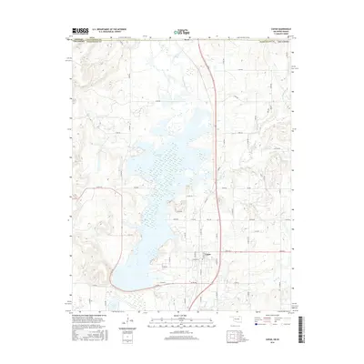
2016 Map of Copan
USGS Topo · Published 2016About this map
Copan Lake dominates this northern Oklahoma landscape, its wide waters and marshy inlets reshaping the drainage of the Little Caney River. To the north, the small settlement of Owen sits just below the Kansas border, while the town of Copan serves as the local hub to the south. The area is defined by a dense network of rural routes such as Wann Rd and N 3980 Rd, illustrating the transition from agricultural tracts to the managed recreational and flood-control landscape of the reservoir. Numerous small tributaries including Cotton Cr, Pooler Cr, and Mud Cr feed into the river system, carving low valleys through the prairie. The town site itself shows a compact street grid including S Caney Ave and W Weldon Ave, positioned near the confluence where Brush Cr meets the main river valley.
Find a feature on this map
51 named features on this map. Tap any name to fly to it.
Don’t see what you’re looking for? This feature index may not catch every label — zoom into the map to look around manually.
Map Details
Editions of this 2016 Copan Map
This is the sole edition of this map. No revisions or reprints were ever made.
Other maps of this area

1885 · Sedan
USGS Topo · 1:125,000

1886 · Independence
USGS Topo · 1:125,000

1889 · Sedan
USGS Topo · 1:125,000

1894 · Independence
USGS Topo · 1:125,000

1901 · Nowata
USGS Topo · 1:125,000

1905 · Independence
USGS Topo · 1:125,000

1909 · Pawhuska
USGS Topo · 1:125,000

1910 · Pawhuska
USGS Topo · 1:125,000

1914 · Nowata
USGS Topo · 1:125,000

1947 · Joplin
USGS Topo · 1:250,000