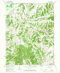
1965 Map of Cope
USGS Topo · Published 1966About this map
Morgantown anchors the southern edge of this mid-1960s survey, where the rolling landscape of Morgan County transitions into a network of creek valleys. The drainage patterns of Stotts Creek and its various forks, including the East Fork, West Fork, and South Fork, dominate the central topography. This era shows a rural landscape punctuated by small crossroads like Exchange and Cope, alongside institutional landmarks such as Township Sch and Pleasant Grove Ch.
Find a feature on this map
66 named features on this map. Tap any name to fly to it.
Don’t see what you’re looking for? This feature index may not catch every label — zoom into the map to look around manually.
Map Details
Editions of this 1965 Cope Map
3 editions found
Other maps of this area

1942 · Franklin
USGS Topo · 1:125,000

1947 · Franklin
USGS Topo · 1:62,500

1948 · Trafalgar
USGS Topo · 1:24,000

1948 · Hindustan
USGS Topo · 1:24,000

1948 · Fruitdale
USGS Topo · 1:24,000

1948 · Morgantown
USGS Topo · 1:24,000

1950 · Morgantown
USGS Topo · 1:24,000

1950 · Franklin
USGS Topo · 1:62,500

1952 · Bargersville
USGS Topo · 1:24,000

1953 · Indianapolis
USGS Topo · 1:250,000