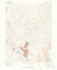
1970 Map of Copper Mountain
USGS Topo · Published 1973About this map
Mining operations and high-altitude infrastructure dominate this landscape at the western edge of the Tenmile Range. The map documents a significant industrial footprint within the mountains, centered on the massive Robinson Tailings Pond and Tenmile Tailings Pond. These features sit adjacent to the historic Kokomo (Site) and Kokomo, marking the remains of silver-and-zinc-era boomtowns that were gradually overtaken by large-scale tailings disposal from nearby molybdenum operations.
Find a feature on this map
69 named features on this map. Tap any name to fly to it.
Don’t see what you’re looking for? This feature index may not catch every label — zoom into the map to look around manually.
Map Details
Editions of this 1970 Copper Mountain Map
4 editions found
Other maps of this area

1889 · Leadville
USGS Topo · 1:125,000

1891 · Leadville
USGS Topo · 1:125,000

1929 · Dillon
USGS Topo · 1:62,500

1934 · Climax
USGS Topo · 1:48,000

1934 · Minturn
USGS Topo · 1:62,500

1934 · Dillon
USGS Topo · 1:62,500

1938 · Mt. Lincoln
USGS Topo · 1:48,000

1942 · Leadville
USGS Topo · 1:125,000

1945 · Mount Lincoln
USGS Topo · 1:62,500

1949 · Holy Cross
USGS Topo · 1:62,500