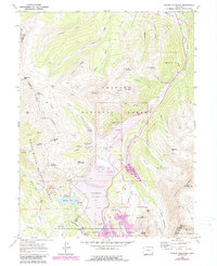
1970 Map of Copper Mountain
USGS Topo · Published 1988About this map
Mining operations and industrial infrastructure dominate this high-altitude landscape where the Continental Divide separates the White River and San Isabel national forests. The former settlement of Kokomo is recorded here amidst a network of heavy industrial sites, including the massive Tenmile and Robinson Tailings Ponds. These features, along with the Oxide Tailings Pond, indicate the intensive scale of mineral extraction in the late 20th century.
Find a feature on this map
85 named features on this map. Tap any name to fly to it.
Don’t see what you’re looking for? This feature index may not catch every label — zoom into the map to look around manually.
Map Details
Editions of this 1970 Copper Mountain Map
4 editions found
Other maps of this area

1889 · Leadville
USGS Topo · 1:125,000

1891 · Leadville
USGS Topo · 1:125,000

1929 · Dillon
USGS Topo · 1:62,500

1934 · Climax
USGS Topo · 1:48,000

1934 · Minturn
USGS Topo · 1:62,500

1934 · Dillon
USGS Topo · 1:62,500

1938 · Mt. Lincoln
USGS Topo · 1:48,000

1942 · Leadville
USGS Topo · 1:125,000

1945 · Mount Lincoln
USGS Topo · 1:62,500

1949 · Holy Cross
USGS Topo · 1:62,500