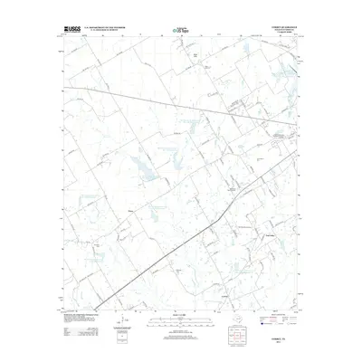
2012 Map of Corbet
USGS Topo · Published 2012About this map
The community of Black Hills and the expansive Odd Fellows and Rebekah Home for Children anchor the northern landscape of this Navarro County region. This 2012 survey documents a rural environment heavily defined by federal water management, featuring a dense network of reservoirs including Soil Conservation Service Site 137g Reservoir and Soil Conservation Service Site 1350 Reservoir designed to control drainage into Briar Creek and Rush Creek. Genealogists and local historians will find significant value in the documentation of numerous family and community burial grounds, such as Cunningham Cemetery and Marshall Cemetery, which are scattered among the settlements of Drane, Corbet, and Oak Valley. The presence of the Anxiety Aerodrome and Resthaven Memorial Park further illustrates the modern infrastructure layered over this traditional agricultural and ranching landscape.
Find a feature on this map
97 named features on this map. Tap any name to fly to it.
Don’t see what you’re looking for? This feature index may not catch every label — zoom into the map to look around manually.
Map Details
Editions of this 2012 Corbet Map
This is the sole edition of this map. No revisions or reprints were ever made.
Other maps of this area

1954 · Dallas
USGS Topo · 1:250,000

1954 · Waco
USGS Topo · 1:250,000

1955 · Waco
USGS Topo · 1:250,000

1956 · Dawson
USGS Topo · 1:24,000

1958 · Dallas
USGS Topo · 1:250,000

1961 · Chatfield
USGS Topo · 1:24,000

1962 · Emhouse
USGS Topo · 1:24,000

1962 · Cryer Creek
USGS Topo · 1:24,000

1963 · Richland
USGS Topo · 1:24,000
1965 · Corsicana
USGS Topo · 1:24,000