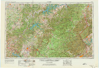
1956 Map of Corbin
USGS Topo · Published 1973About this map
Lake Cumberland and the Cumberland River anchor this mid-century view of the Cumberland Plateau, where the rugged topography of southern Kentucky and north-central Tennessee meets significant post-war development. The map reveals the critical intersection of natural preservation and industrial growth, featuring the expansive Cumberland National Forest alongside the burgeoning scientific and industrial hub at Oak Ridge. Extensive hydroelectric and recreation projects are evident through the footprints of Dale Hollow Lake, Center Hill Lake, and Norris Lake.
Find a feature on this map
67 named features on this map. Tap any name to fly to it.
Don’t see what you’re looking for? This feature index may not catch every label — zoom into the map to look around manually.
Map Details
Editions of this 1956 Corbin Map
3 editions found

Other maps of this area

1886 · Knoxville
USGS Topo · 1:125,000

1886 · Cumberland Gap
USGS Topo · 1:125,000

1887 · Kingston
USGS Topo · 1:125,000

1888 · Cumberland Gap
USGS Topo · 1:125,000

1890 · Williamsburg
USGS Topo · 1:125,000

1891 · Manchester
USGS Topo · 1:125,000

1891 · Cumberland Gap
USGS Topo · 1:125,000

1891 · Kingston
USGS Topo · 1:125,000

1892 · Pikeville
USGS Topo · 1:125,000

1892 · Knoxville
USGS Topo · 1:125,000