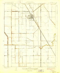
1928 Map of Corcoran
USGS Topo · Published 1928About this map
The agricultural grid of the San Joaquin Valley is meticulously documented in this late 1920s survey, focused on the hub of Corcoran and its southern extension at South Corcoran. This era captures the landscape as it transitioned through intensive irrigation engineering, with the Atchison Topeka and Santa Fe railroad cutting diagonally across a terrain defined by an intricate network of water management. The map details vital infrastructure like the Sweet Canal, North Corcoran Ditch, and Fisk DITCH.
Find a feature on this map
32 named features on this map. Tap any name to fly to it.
Don’t see what you’re looking for? This feature index may not catch every label — zoom into the map to look around manually.
Map Details
Editions of this 1928 Corcoran Map
3 editions found
Other maps of this area

1914 · Lost Hills
USGS Topo · 1:125,000

1927 · Lake View School
USGS Topo · 1:31,680

1927 · Paige
USGS Topo · 1:31,680

1928 · Waukena
USGS Topo · 1:31,680

1928 · Corcoran
USGS Topo · 1:31,680

1929 · Alpaugh
USGS Topo · 1:31,680

1929 · Guernsey
USGS Topo · 1:31,680

1929 · West Alpaugh
USGS Topo · 1:31,680

1931 · Harvester
USGS Topo · 1:31,680

1932 · El Rico Ranch
USGS Topo · 1:31,680