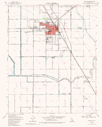
1954 Map of Corcoran
USGS Topo · Published 1987About this map
The agricultural landscape of the Tulare Lake Bed dominates this mid-century survey, revealing a region defined by complex water management and industrial farming. Large-scale operations are evident through the numerous Levee systems and irrigation networks like the Corcoran Canal and Sweet Canal, which support the intensive cultivation of former lake land. The town of Corcoran serves as the central hub, housing significant infrastructure including multiple grain elevators, the Corcoran Airport, and several primary and secondary schools such as John Muir Jr HS and Bret Harte School.
Find a feature on this map
60 named features on this map. Tap any name to fly to it.
Don’t see what you’re looking for? This feature index may not catch every label — zoom into the map to look around manually.
Map Details
Editions of this 1954 Corcoran Map
3 editions found
Other maps of this area

1914 · Lost Hills
USGS Topo · 1:125,000

1927 · Lake View School
USGS Topo · 1:31,680

1927 · Paige
USGS Topo · 1:31,680

1928 · Waukena
USGS Topo · 1:31,680

1928 · Corcoran
USGS Topo · 1:31,680

1929 · Alpaugh
USGS Topo · 1:31,680

1929 · Guernsey
USGS Topo · 1:31,680

1929 · West Alpaugh
USGS Topo · 1:31,680

1931 · Harvester
USGS Topo · 1:31,680

1932 · El Rico Ranch
USGS Topo · 1:31,680