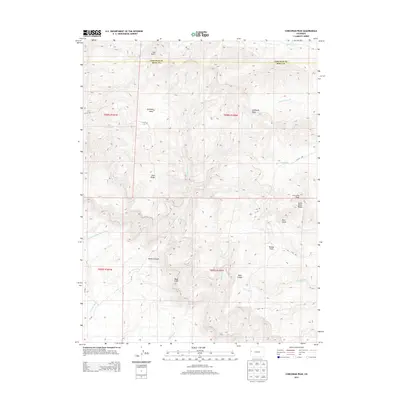
2013 Map of Corcoran Peak
USGS Topo · Published 2013About this map
Corcoran Peak and the high desert terrain along the border of Mesa and Garfield counties dominate this landscape. The sheer escarpment of the Book Cliffs cuts through the southern portion of the sheet, creating a dramatic physical divide between the upper plateaus and the lower basin drainage. A complex network of ephemeral waterways, including Little Salt Wash, Adobe Creek, and Jerry Creek, has carved deep incisions into the land, forming named landmarks like Hunter Canyon and Main Canyon. High-altitude features such as Garfield Mesa and Bronco Flats suggest a geography defined by broad, flat uplands separated by steep draws. Sparse infrastructure like V 8/10 Rd and Q 9/10 Rd provides limited access to these ridges and gulches, highlighting the area's primary use for land management and resource exploration over settlement.
Find a feature on this map
28 named features on this map. Tap any name to fly to it.
Don’t see what you’re looking for? This feature index may not catch every label — zoom into the map to look around manually.
Map Details
Editions of this 2013 Corcoran Peak Map
This is the sole edition of this map. No revisions or reprints were ever made.
Other maps of this area

1929 · Roan Creek
USGS Topo · 1:62,500

1956 · Grand Junction
USGS Topo · 1:250,000

1959 · Grand Junction
USGS Topo · 1:250,000

1960 · Grand Junction
USGS Topo · 1:250,000

1962 · Grand Junction
USGS Topo · 1:250,000

1962 · Fruita
USGS Topo · 1:24,000
1962 · Round Mountain
USGS Topo · 1:24,000

1962 · Corcoran Point
USGS Topo · 1:24,000

1964 · Grand Junction
USGS Topo · 1:250,000

1965 · Grand Junction
USGS Topo · 1:250,000