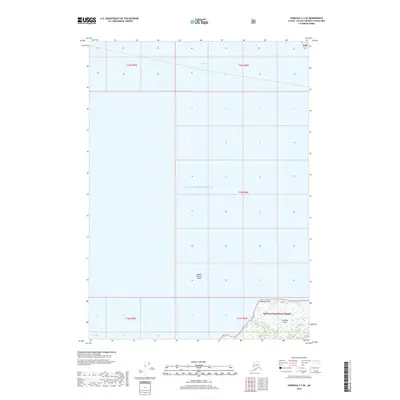
2018 Map of Cordova C-7 SE
USGS Topo · Published 2018About this map
Chugach National Forest land and the waters of Prince William Sound define this maritime environment near the port of Cordova. The coastal geography is dominated by the northern shoreline of Hawkins Island, where Makarka Point and the tidal drainage of Makarka Cr meet the sea. This 2018 survey illustrates the complex hydrography of the region, specifically focusing on the navigable transition between Orca Bay and the open sound. Navigation and local maritime history are tied to features like the Middle Ground Shoal, which dictates vessel passage through these northern Alaskan waters. The map primarily records the natural coastline and federally protected forest boundaries rather than modern infrastructure, emphasizing the wild character of the eastern sound.
Find a feature on this map
12 named features on this map. Tap any name to fly to it.
Don’t see what you’re looking for? This feature index may not catch every label — zoom into the map to look around manually.
Map Details
Editions of this 2018 Cordova C-7 SE Map
This is the sole edition of this map. No revisions or reprints were ever made.
Other maps of this area

1948 · Cordova
USGS Topo · 1:250,000

1950 · Cordova C-7
USGS Topo · 1:63,360

1950 · Cordova C-6
USGS Topo · 1:63,360

1950 · Cordova B-7
USGS Topo · 1:63,360

1951 · Cordova
USGS Topo · 1:250,000

1951 · Cordova B-6
USGS Topo · 1:63,360

1953 · Cordova C-6
USGS Topo · 1:63,360

1953 · Cordova B-7
USGS Topo · 1:63,360
1953 · Cordova C-7
USGS Topo · 1:63,360

1953 · Cordova B-6
USGS Topo · 1:63,360