
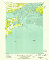
1953 Map of Cordova B-6
USGS Topo · Published 1954About this map
Orca Inlet serves as a central waterway in this coastal survey, where the rugged maritime economy of the early 1950s is evidenced by several canneries and a Radio Range Sta at Strawberry Hill. The landscape is dominated by the massive landforms of Hawkins Island and Hinchinbrook Island, separated by the Hawkins Island Cutoff. Navigation aids and infrastructure define the shoreline near Whiteshed, including several Radio Towers and a survey marker at VABM Camp.
Find a feature on this map
31 named features on this map. Tap any name to fly to it.
Don’t see what you’re looking for? This feature index may not catch every label — zoom into the map to look around manually.
Map Details
Editions of this 1953 Cordova B-6 Map
2 editions found
Other maps of this area

1948 · Cordova
USGS Topo · 1:250,000

1950 · Cordova C-7
USGS Topo · 1:63,360

1950 · Cordova C-6
USGS Topo · 1:63,360

1950 · Cordova B-7
USGS Topo · 1:63,360

1951 · Cordova
USGS Topo · 1:250,000

1951 · Cordova C-5
USGS Topo · 1:63,360

1951 · Cordova B-5
USGS Topo · 1:63,360

1951 · Cordova B-6
USGS Topo · 1:63,360

1953 · Cordova C-6
USGS Topo · 1:63,360

1953 · Cordova B-7
USGS Topo · 1:63,360