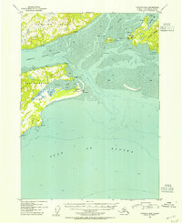
1953 Map of Cordova B-6
USGS Topo · Published 1964About this map
The maritime approaches to Prince William Sound are defined here by the complex tidal flats of Orca Inlet and the southern reaches of Hawkins Island. Mapping based on 1953 photography illustrates a landscape dominated by shifting shoals and mudflats, where the Hawkins Island Cutoff and Boswell Bay separate major landmasses. Navigation and communication are the primary human signatures on this coastal environment, evidenced by the Whitshed Radio Towers at Pt Whitshed and a Radio Range Sta situated on Strawberry Hill. The presence of Canneries along the shoreline of Hartney Bay highlights the region's historical reliance on the salmon industry. The southern edge of the survey transitions abruptly into the Gulf of Alaska, marked by hazardous coastal points such as Pt Steele and Hook Pt.
Find a feature on this map
25 named features on this map. Tap any name to fly to it.
Don’t see what you’re looking for? This feature index may not catch every label — zoom into the map to look around manually.
Map Details
Editions of this 1953 Cordova B-6 Map
2 editions found

Other maps of this area

1948 · Cordova
USGS Topo · 1:250,000

1950 · Cordova C-7
USGS Topo · 1:63,360

1950 · Cordova C-6
USGS Topo · 1:63,360

1950 · Cordova B-7
USGS Topo · 1:63,360

1951 · Cordova
USGS Topo · 1:250,000

1951 · Cordova C-5
USGS Topo · 1:63,360

1951 · Cordova B-5
USGS Topo · 1:63,360

1951 · Cordova B-6
USGS Topo · 1:63,360

1953 · Cordova C-6
USGS Topo · 1:63,360

1953 · Cordova B-7
USGS Topo · 1:63,360